GNSS Radio Occultation
GNSS-RO is a satellite remote sensing technique that uses GNSS (e.g. GPS) measurements received by a low-Earth orbiting satellites to profile the Earth's atmosphere and ionosphere with high vertical resolution and global coverage. The high accuracy and vertical resolution of GNSS-RO data make them ideally suited to study:
- Weather forecasting and atmospheric processes
- Climate monitoring and model verification
- Space weather and ionospheric research
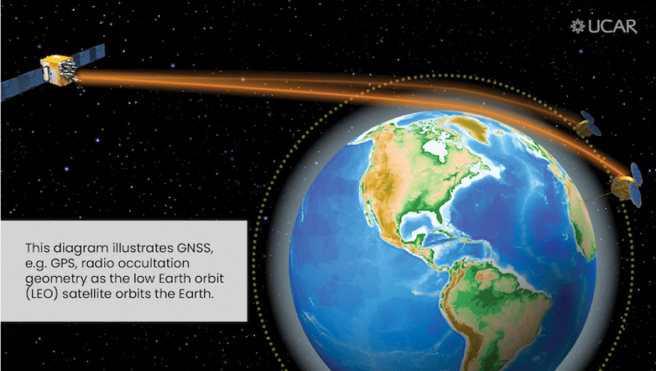
The science behind radio occultation was developed in the 1960s to study the atmospheres of the outer planets of the solar system. More recently, scientists have begun to apply radio occultation to study the Earth's atmosphere. The method works by taking advantage of radio signals broadcast from GNSS satellites already in orbit. As radio signals from the GPS satellites pass through the atmosphere, molecules and electrons bend their paths and slow their progress. COSMIC takes advantage of this effect by intercepting the radio signals and measuring their bending and signal delay. The satellites then downlink the data at ground stations in Fairbanks, Alaska; Tromso, Norway; and McMurdo, Antarctica. Once the data are relayed back to the COSMIC Data Analysis and Archive Center (CDAAC) in Boulder, scientists retrieve profiles of bending angles, refractivity, temperature, pressure, and water vapor in the atmosphere and of electron density in the ionosphere. The COSMIC RO profiles start near Earth's surface and extend to the height of the COSMIC satellites at 800 kilometers (500 miles) above Earth. Since the six COSMIC-1 satellites are distributed equally in local time around the Earth, COSMIC provides homogeneous sampling coverage that operational weather balloons and monitoring stations can not match, especially over the oceans and other areas traditionally sparse in data.
The unique properties of GNSS-RO include:
- Assured long-term stability
- All-weather operation
- Global 3-D coverage: 40 km to the surface
- Vertical resolution: ~100 m in the lower troposphere
- Independent height, pressure, and temperature data
- A compact, low-power, low-cost sensor
- High accuracy: Averaged profiles to < 0.1 K
"The independent nature of radio occultation soundings make them highly complementary to other atmospheric sounding systems, such as infrared and microwave sounders", says Rick Anthes, UCAR President Emeritus. "Two or three independent sounding systems, when combined properly, can yield atmospheric soundings of temperature and water vapor with higher accuracy and vertical and horizontal resolution than any one system alone".
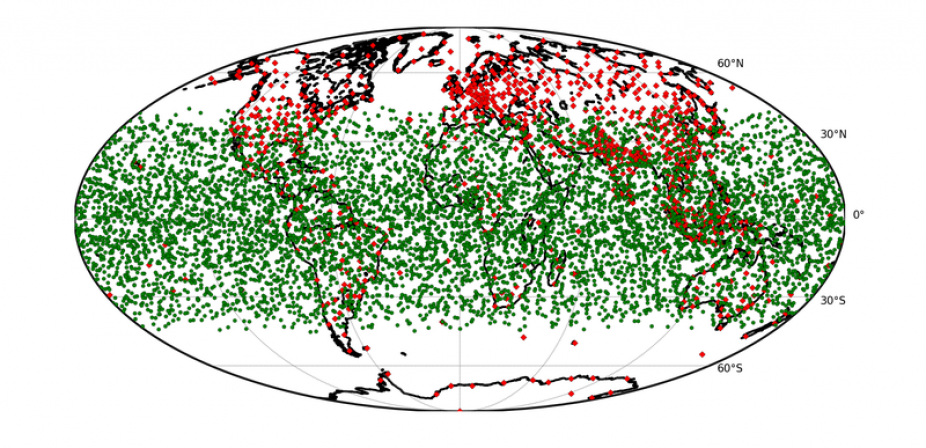
The daily geographic coverage of COSMIC-2 is shown below. The operational COSMIC-2 Data Processing Center at UCAR will process raw COSMIC-2 data and disseminate environmental data records to the operational and research communities in near real-time.
UCAR demonstrated the potential of using radio occultation to sound Earth's atmosphere with the GPS/MET experiment from 1995 to 1997. COSMIC-1 built on GPS/MET and subsequent radio occultation missions to produce real-time soundings that are currently used in operational weather prediction models. We are now working on the COSMIC-2 constellation.